Itinerànnia
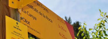
A network of paths that recovers the paths that were used to go from one village to another. 3,000 kilometers marked with yellow markings. From the Pyrenees to the sea.
The basic network (yellow signals with red tip) connects 108 municipalities. There are also specific circular routes linked to the networks around the municipalities (yellow signs with the green tip)
CONCTACT INFORMATION
Itinerànnia
Experiences what offers
-
The network of trails from the Pyrenees to the sea
The network of trails offers from proposals of circular or linear itineraries of different difficulties, there are about 200. There is the the possibility of making your own route with the tool of creation of routes, this tool allows you make a route and also look for information on the services closest to the route that you will find digitalized. With this tool you can create your own custom journey.
Other experiences and services related
-
Productedelripolles
- Activities
- Ripollès - Girona
We are professional producers and processors who are part of the Ripollès Product Association (...)
-
Eva Martínez Picó
- Activities
- Ripollès - Girona
Domini d 'Isards is a trail running and hiking station in Espinavell, Pyrenees-Orientales. We organize (...)


